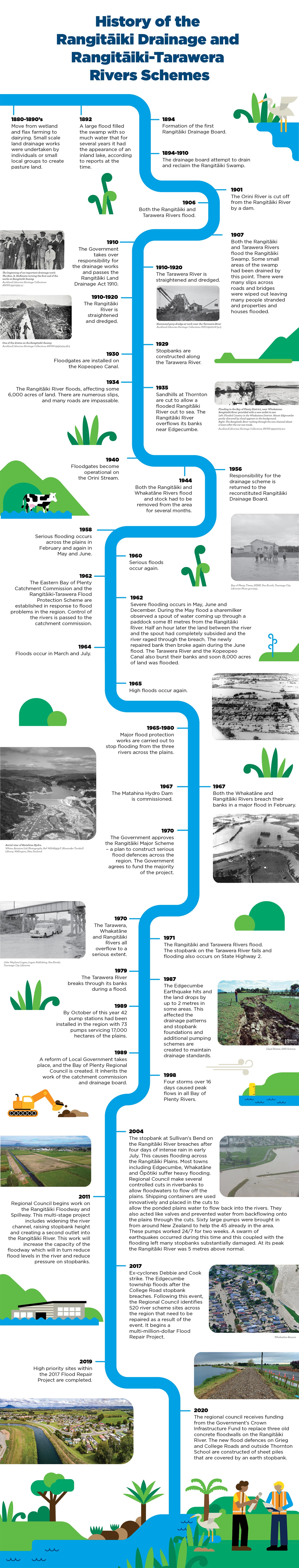
Rangitāiki-Tarawera Rivers Scheme
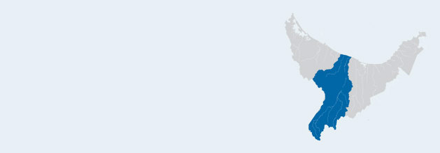
The Rangitāiki-Tarawera Rivers Scheme covers the Rangitāiki River with a 3005km2 catchment and the Tarawera River with a 984km2 catchment.
This is our biggest Rivers Scheme, and extends all the way down to Rangitāiki in the Taupō District, covering Murupara, Galatea, Waiohau, Te Teko, Kawerau, Edgecumbe and Thornton. It covers rivers streams and tributaries in the area, as well as the region’s longest river – the Rangitāiki – which is 155km long.
It also includes some of the Rotorua Lakes, such as Tarawera, Ōkāreka, Ōkataina, and Tikitapu.
It is one of five major Rivers Schemes that were established in the 1970s by Regional Council (then known as the Catchment Commission) to effectively manage and maintain the flood defences along the awa, to help protect the lives and livelihoods of the community.
Andrew Pawson, Rangitāiki - Tarawera River Scheme Area Engineer, tells us more:

This scheme includes:
Bay of Plenty Regional Council owns and manages an array of flood protection and drainage defences across the rohe (such as stopbanks, floodgates, floodwalls etc).
As well as developing new or improved flood defences, our team undertake regular work to test, check, repair and maintain these defences.
We do this to make sure they are in good condition, so that when a flood event occurs, the flood defences will help manage the impacts to the community.


All ratepayers across the region contribute to river and drain management. However, if you live within a scheme, you pay an additional targeted rate for the services that you directly benefit from (such as flood protection and drainage).
Find out more information about the River Scheme, Pump & Drainage Scheme targeted rates.
Latest rainfall and river levels
For current rainfall and river levels, visit the Environmental Data Portal.
Your River Scheme Advisory Group
Flood protection is an ongoing conversation with the community, to help balance the social, cultural, economic and environmental impacts that flood protection presents.
To help achieve this, we established River Advisory Groups, which are made up of local people from along the river with different interest and involvements in the future of the awa. These locals are here to represent your needs and wants for the awa, which helps advise our teams when it comes to flood projects, maintenance and management.
Find out more the Rangitāiki-Tarawera Rivers Scheme Advisory Group.
Co-governance forum
The Rangitāiki River Forum was formed in May 2012 by law to protect and enhance the mauri (life-giving capacity) of the Rangitāiki River and its tributaries.
Find out more about the Rangitāiki River Forum.